


Unlocking Snow-Depth Measurements With GNSS-R to Understand Climate
Snow, a simple blanket of white, holds significance in the context of climate change. Understanding its distribution and depth is critical in understanding the planet’s health and overall climate variability.
NOTE: The views expressed here are solely those of the author and/or interview subject and do not represent positions of IEEE. Some references may require subscription to access content.
|
Organizations concerned with snow and ice include:
IEEE Geoscience and Remote Sensing Society (GRSS) members work in the geosciences including hydrology and meteorology. IEEE GRSS Remote Sensing Environment, Analysis, Climate Change Technical Committee (REACT) is a venue for sharing ideas about technology solutions to mitigate the impact of climate change within the GRSS fields of interest. World Meteorological Organization (WMO) coordinates efforts related to weather, climate, and water. National Snow and Ice Data Center (NSIDC) is an international resource that provides data and information on snow cover and depth. European Space Agency (ESA) and National Aeronautics and Space Administration (NASA) operate several satellites that monitor snow cover and depth, as well as collaborate on research initiatives. European Environment Agency (EEA) reports assessments on snow and ice monitoring in Europe. Canadian Cryospheric Information Network (CCIN) provides data and tools related to snow and ice monitoring in Canada and globally. International Arctic Science Committee (IASC) promotes Arctic research collaborations around the world. |
Snow plays a crucial role in shaping habitats and sustaining biodiversity. Many species, from plants to animals, rely on snow cover for insulation, shelter, and as a source of water. Disruptions in snow patterns can alter species distribution, migration routes, and food availability, triggering ripple effects throughout the ecosystems.
Snow, often viewed as a simple blanket of white, holds significance in the context of climate change. Understanding its distribution and depth are critical factors in understanding the planet’s health and overall climate variability.
As the snow coverage changes, it becomes even more critical to accurately measure its coverage and depth across the globe.
Technology is helping to gain a better picture of the snow layer’s distribution and depth. Traditionally, acquiring accurate snow-depth data has been challenging due to such issues as spatial variability where snow depth can vary over short distances due to wind, temperature changes, and terrain, or with sublimation where the snow vaporizes, making accurate measurements over time difficult. With the advent of technology like Global Navigation Satellite System-Reflectometry (GNSS-R), scientists now have a powerful tool to measure snow depths [ 1 ] more accurately.
GNSS-R is a satellite remote sensing technique that uses surface-reflected signals to infer information about the Earth’s surface. The reflected GNSS signals act as a bi-static remote sensing radar. Instead of using traditional methods that rely on transmitting and receiving signals directly from satellites, GNSS-R utilizes signals reflected off surfaces, like oceans, forests, and, critically, snow-covered terrain to better understand geophysical properties.
The principle behind using GNSS-R to measure snow depth lies in the unique way snow interacts with satellite signals. As GNSS signals penetrate the snowpack, they undergo reflection and scattering, with some of the signals bouncing back toward the satellites. By analyzing these reflected signals, scientists can derive valuable information about the characteristics of the snow layer [ 2 ].
IEEE published IEEE Standard 4003™ for Spaceborne Global Navigation Satellite System-Reflectometry Data and Metadata Content [ 3 ], which provides a set of specifications that can be used to describe any known and future GNSS-R data sets, allowing users to work with different data sets at the same time.
One of the key advantages of GNSS-R is its ability to provide measurements over large areas with high spatial resolution. This capability is particularly valuable in regions with diverse topography and variable snow-accumulation patterns, where traditional measurement methods may be impractical.
By continuously monitoring snow depth over time and across different geographical regions, scientists can track trends in snow coverage and duration. This data is essential for assessing seasonal snow patterns and identifying areas susceptible to changes in snowfall and melting rates.
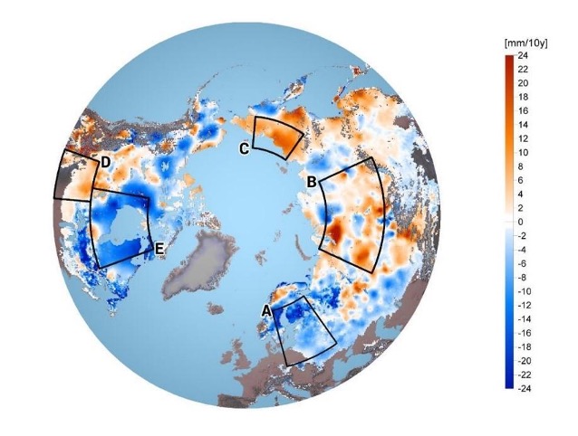
Figure 1: Changes in snow mass, both increases and decreases, between 1980 and 2018, as reported by the European Space Agency.
Snow water equivalent (SWE) is a critical parameter for assessing water resources [ 4 ], especially in regions where snowmelt contributes significantly to streamflow and water availability. GNSS-R, as well as GPS (Global Position System), enable more accurate estimation of SWE by providing measurements of snow depth combined with knowledge of snow density.
While GNSS-R offers promising opportunities, several challenges remain. These include refining algorithms for extracting snow-depth information from GNSS-R data and limitations in signal penetration and resolution, particularly in complex terrain. These are key areas where scientists and engineers are collaborating to find solutions.
Incorporating accurate snow-depth data into climate models enhances their predictive capabilities. By refining snow parameters within these models, researchers can improve projections of future climate scenarios and better anticipate the potential impacts on ecosystems and society.
[1] Y. Hu, X. Yuan, W. Liu, Q. Hu, J. Wickert and Z. Jiang, “An SVM-Based Snow Detection Algorithm for GNSS-R Snow Depth Retrievals,” in IEEE Journal of Selected Topics in Applied Earth Observations and Remote Sensing, vol. 15, pp. 6046-6052, 2022, doi: 10.1109/JSTARS.2022.3193113.
[2] K. Yu, Y. Li, X. Chang, S. Wang and K. Zhang, “Snow Depth Estimation Using Pseudorange and Carrier Phase of GNSS Signals,” 2018 International Conference on Electromagnetics in Advanced Applications (ICEAA), Cartagena, Colombia, 2018, pp. 39-42, doi: 10.1109/ICEAA.2018.8520444.
[3] “IEEE Standard for Spaceborne Global Navigation Satellite System-Reflectometry (GNSS-R) Data and Metadata Content,” in IEEE Std 4003-2021, pp.1-27, 1 Nov. 2021, doi: 10.1109/IEEESTD.2021.9594781.
[4] L. Steiner, M. Meindl, C. Fierz, C. Marty and A. Geiger, “Monitoring snow water equivalent using low-cost GPS antennas buried underneath a snowpack,” 2019 13th European Conference on Antennas and Propagation (EuCAP), Krakow, Poland, 2019, pp. 1-5.