
TECHNOLOGY IS PIVOTAL IN RESHAPING FRESHWATER SECURITY
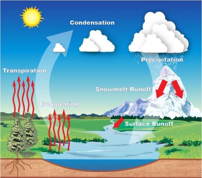
The water cycle is an ongoing and dynamic process that ensures the availability of freshwater on Earth. It is essential for sustaining life, maintaining ecosystems, and providing a continuous supply of water.
NOTE: The views expressed here are solely those of the author and/or interview subject and do not represent positions of IEEE. Some references may require subscription to access content.
The United Nations has set ambitious targets under the Sustainable Development Goals to ensure universal access to safe and affordable drinking water to all by 2030. This includes improving water quality, reducing water scarcity, and promoting water-use efficiency.
Lack of access to clean water is a major public health issue. Contaminated water sources can lead to diseases such as cholera, dysentery, and diarrhea, which can be fatal, especially for children. Changing precipitation patterns and increasing water stress can make access to clean water more challenging in many regions of the world. Depletion of aquifers is an additional contributor to water scarcity.
Fortunately, technology is playing a pivotal role in addressing these challenges and reshaping the future of freshwater security.
The water cycle, also known as the hydrological cycle, is a continuous and natural process that describes the movement of water on, above, and below the Earth’s surface. It involves various stages, including precipitation, evaporation, and the replenishment of groundwater. Understanding the balance and flow of water between its different forms and reservoirs is crucial for both environmental and human well-being.
Rabia Munsaf Khan is a member of the IEEE Young Professionals Climate Change and Sustainability Task Force and the IEEE Geoscience and Remote Sensing Society (GRSS). Originally from Pakistan, Khan is a Fulbright scholar with a degree in environmental resource engineering and a specialization in geospatial information science. She is pursuing a Ph.D. in water quality from the State University of New York (SUNY) in Syracuse. “In my work, I use machine learning and remote sensing and observation techniques to monitor water quality in lakes and freshwater to ensure quality drinking water,” she says.
Freshwater lakes, for example, are susceptible to algae bloom contaminations. Often caused by excessive levels of nitrogen and phosphorus from agricultural run-off, algae blooms have negative impacts, including the production of harmful toxins and oxygen depletion in water bodies, as well as harm to aquatic ecosystems and reduced water quality for drinking and recreational purposes.
Detecting and monitoring algae blooms in freshwater lakes is crucial for managing water quality and safeguarding aquatic ecosystems. Various technologies and methods are employed to detect and track algae blooms.
Advanced sensor technologies and data analytics are revolutionizing this field. Remote sensing of water bodies can continuously measure parameters such as temperature, pH, dissolved oxygen, and pollutant levels. These sensors transmit real-time data, enabling authorities to detect contamination events promptly. “When we have a bird’s-eye view from satellite imagery, we can pinpoint many things. For example, which tributaries are contributing most in terms of sediments,” says Khan.
Technologies are continually advancing. In their paper “UAVs vs Satellites: Comparison of tools for water quality monitoring [ 1 ],” published at the 2022 IEEE 13th Latin America Symposium on Circuits and System (LASCAS), the authors report that while satellite-based remote-sensing imagery remains broadly as the method for monitoring water quality and algae blooms, it has some limitations. Unmanned aerial vehicles (UAVs) have emerged as an effective alternative with potential for better results.
Artificial intelligence (AI)–driven algorithms can process vast amounts of data to predict water quality trends and identify potential pollution sources. By tracking historical data and current conditions, AI can predict and mitigate contamination risks, safeguarding both public health and ecosystems.
The authors’ objective in the conference paper “In Situ Water Quality Data for the Chesapeake Bay[ 2 ],” published at IGARSS 2022 – 2022 IEEE International Geoscience and Remote Sensing Symposium, is to use in-situ data as ground truth to provide water quality classifications, or labels, to their overlapping satellite imagery. The goal is to train AI models to recognize features in spectral information for monitoring water quality from satellites.
Khan speaks to deforestation and urbanization as contributors to upsetting the hydrological cycle. “Groundwater is like a bowl. It needs to be filled at the same rate that it is being used,” she says. Urbanization in the form of concrete and paved roads prevents rainwater from being reabsorbed in the Earth. In some urban environments, the water is captured and cycled through treatment facilities, but this is not true in all parts of the world. “It is critical that the hydrological cycle remains in balance. Every patch of green space can assist in refilling the aquifer bowl,” says Khan.
Droughts are characterized by an extended period of deficient precipitation and water scarcity. They can have significant impacts on ecosystems, agriculture, and water supply. Typically, drought begins with meteorological drought, after which is agricultural and hydrological drought. In the paper “Satellite Data-Driven Deep Learning Approach for Monitoring Groundwater Drought in South Korea[ 3 ],” published at the IGARSS 2022 – 2022 IEEE International Geoscience and Remote Sensing Symposium, the authors explain the need to investigate the process involved in the drought propagation from meteorological to groundwater drought using modern technologies.
Coming from Pakistan, Khan’s background blends science and engineering with her cultural heritage. The insight from a developing country benefits her research. She says that her work relies on collaboration with others, too. “Collaborate, collaborate, collaborate. Get insights from various perspectives from a diverse set of inputs to analyze the problem for the best solutions, while keeping true to ethics. We think that we are supposed to do everything ourselves, but we cannot, so collaboration is key,” she says. IEEE is a perfect forum for such collaborations.
Below are questions answered by Rabia Munsaf Khan:
Are there any emerging technologies or solutions that are particularly promising for addressing water security challenges in the context of climate change? How do they work?
Khan:
- Agricultural Water Management Techniques: Climate-resilient agricultural practices include precision irrigation, drought-resistant crop varieties, and improved soil management. These techniques optimize water use and reduce agricultural water waste, ensuring food production in changing climate conditions.
- Cloud Seeding and Weather Modification: Cloud seeding involves the introduction of substances like silver iodide into clouds to enhance precipitation, potentially increasing water resources in water-scarce regions. It is particularly relevant in arid areas.
- Solar Desalination: Solar desalination systems use solar energy to purify seawater or brackish water. Solar stills, multi-effect distillation, and solar-assisted reverse osmosis are methods that leverage the sun’s power to provide fresh water.
- Fog Harvesting: Fog harvesting captures moisture from the air using specially designed nets or meshes. When the captured fog droplets coalesce and form larger droplets, they can be collected and used as a source of freshwater, particularly in arid regions.
- Blockchain for Water Management: Blockchain technology can be used to create transparent and secure water-management systems. It ensures accurate recordkeeping and accountability in water allocation and transactions.
- Artificial Intelligence and Machine Learning: AI and ML models process massive datasets to predict and manage water resources more efficiently. They offer insights into water demand, quality, and availability, helping optimize distribution and reduce waste.
- Rainwater Harvesting: Rainwater harvesting systems collect and store rainwater for various uses. They are particularly valuable in regions with seasonal rainfall variations.
[1] E. Pacilio, A. Silvarrey and A. Pardo, “UAVs vs Satellites: Comparison of tools for water quality monitoring,” 2022 IEEE 13th Latin America Symposium on Circuits and System (LASCAS), Puerto Varas, Chile, 2022, pp. 1-4, doi: 10.1109/LASCAS53948.2022.9789059.
[2] N. Memarsadeghi, S. S. Uz, J. R. McKay and B. Santana, “In Situ Water Quality Data for the Chesapeake Bay,” IGARSS 2022 – 2022 IEEE International Geoscience and Remote Sensing Symposium, Kuala Lumpur, Malaysia, 2022, pp. 6876-6879, doi: 10.1109/IGARSS46834.2022.9884625.
[3] J. Y. Seo and S. -I. Lee, “Satellite Data-Driven Deep Learning Approach for Monitoring Groundwater Drought in South Korea,” IGARSS 2022 – 2022 IEEE International Geoscience and Remote Sensing Symposium, Kuala Lumpur, Malaysia, 2022, pp. 6312-6315, doi: 10.1109/IGARSS46834.2022.9884120.